
The Great Pyramid of Giza has long been a subject of fascination, but its story raises more questions than answers. Conventional history attributes its construction to Pharaoh Khufu around 2500 BCE, using 20,000 workers, copper chisels, and ropes to place over 2.3 million stones in just 20 years. Yet, the pyramid’s features challenge this narrative. Some blocks, weighing up to 80 tons, were quarried hundreds of miles away and lifted over 150 feet into place. The foundation, spanning 13 acres, is leveled to within an inch, a precision modern engineers struggle to replicate. The pyramid is aligned to true north with an accuracy of 0.05°, achievable today only with satellite technology. Additionally, an unexplored chamber, the size of an airplane hangar, remains hidden within.

Graham Hancock, over three decades, investigated these anomalies, uncovering evidence that challenges mainstream history. The absence of Khufu’s name within the pyramid is striking. Unlike other pharaohs who adorned their tombs with hieroglyphs and treasures, the Great Pyramid’s chambers are bare, and the granite box in the King’s Chamber shows no evidence of ever holding a body. The only link to Khufu comes from red-painted marks found in 1837 by Colonel Howard Vyse in a hidden chamber, but their authenticity is questionable due to Vyse’s inconsistent notes and the pressure he faced to make a discovery. If these marks were forged, the connection to Khufu vanishes.

The pyramid’s precision further deepens the mystery. Its base is leveled with near-perfect accuracy, and many blocks are cut so precisely that a razor blade cannot fit between them. Copper tools, too soft to cut granite, could not have achieved this, as experiments have shown. Moving 80-ton blocks from Aswan, 500 miles away, would be a monumental task even with modern cranes. To meet the 20-year timeline, workers would have needed to place a block every 2.5 minutes, nonstop, for two decades—an implausible feat with ancient tools. The ramp theory, suggesting massive ramps were used to haul stones, lacks evidence, as no remnants of such structures exist.

Inside, the pyramid’s design is equally enigmatic. The Grand Gallery’s unique architecture and the King’s Chamber’s relieving chambers, stacked with 50-ton granite beams, suggest engineering far beyond a simple tomb. The pyramid’s dimensions encode mathematical constants like pi and reflect astronomical alignments, such as the solar year and Earth’s curvature. Hancock argues it was not a tomb but a message in stone, designed to preserve knowledge across time.

Later Egyptian pyramids, inferior in quality and often crumbling, suggest a decline rather than progress in construction techniques. This raises the possibility that the Great Pyramid was inherited, not built, by the Egyptians. Geological evidence supports this. The Great Sphinx, part of the Giza complex, shows erosion from heavy rainfall, unseen in Egypt for over 10,000 years, dating it to around 10,500 BCE. The pyramids’ alignment with Orion’s Belt also matches the sky in 10,500 BCE, not 2500 BCE, suggesting an ancient origin.
Hancock proposes the pyramid was built by survivors of a lost civilization, possibly destroyed during the Younger Dryas cataclysm around 12,800 years ago, when a comet impact triggered global floods and chaos. Similar architectural patterns—pyramids in Mexico, temples in Cambodia, megaliths in Turkey—suggest a shared knowledge across ancient cultures. Hancock calls these “fingerprints of the gods,” evidence of a forgotten civilization.

Unexplored discoveries, like a stone door found in a shaft in 1993 and a massive void detected in 2017, hint at more secrets. Hancock suggests these are suppressed to avoid rewriting history. He views the Great Pyramid not as a tomb but as a time capsule, meant to endure disasters and preserve knowledge. If true, it challenges our understanding of human history, suggesting we are a “species with amnesia.” The question remains: Was the Great Pyramid built by Khufu, or is it the legacy of a lost civilization?
The Indonesian archipelago is host to some of the earliest known rock art in the world1,2,3,4,5. Previously, secure Pleistocene dates were reported for figurative cave art and stencils of human hands in two areas in Indonesia—the Maros-Pangkep karsts in the southwestern peninsula of the island of Sulawesi1,3,4,5 and the Sangkulirang-Mangkalihat region of eastern Kalimantan, Borneo2. Here we describe a series of early dated rock art motifs from the southeastern portion of Sulawesi. Among this assemblage of Pleistocene (and possibly more recent) motifs, laser-ablation U-series (LA-U-series) dating of calcite overlying a hand stencil from Liang Metanduno on Muna Island yielded a U-series date of 71.6 ± 3.8 thousand years ago (ka), providing a minimum-age constraint of 67.8 ka for the underlying motif. The Muna minimum (67.8 ± 3.8 ka) exceeds the published minimum for rock art in Maros-Pangkep by 16.6 thousand years (kyr) (ref. 5) and is 1.1 kyr greater than the published minimum for a hand stencil from Spain attributed to Neanderthals6, which until now represented the oldest demonstrated minimum-age constraint for cave art worldwide. Moreover, the presence of this extremely old art in Sulawesi suggests that the initial peopling of Sahul about 65 ka7 involved maritime journeys between Borneo and Papua, a region that remains poorly explored from an archaeological perspective.

A noteworthy finding of the past decade has been the discovery and dating of Pleistocene-aged rock art in Sulawesi, the largest island in Wallacea—the oceanic island zone separating the continental regions of Southeast Asia (Sunda) and Australia–New Guinea (Sahul)—and on the edge of the Sunda continental shelf (present-day Borneo) to its immediate west1,2,3,4,5,8. In Sulawesi, U-series dating of rock art motifs (n = 23), including hand stencils (n = 13) and figurative paintings of animals (n = 7) and anthropomorphs (n = 3), has yielded minimum ages ranging from 51.2 kyr to 17 kyr (refs. 1,2,3,4,5). All of the dated rock art sites are located in the approximately 450 km2 lowland ‘tower’ karst region of Maros-Pangkep in the southwestern peninsula of Sulawesi. On the opposing southern peninsula, known as Southeast Sulawesi, an area that includes several satellite islands, the presence of rock art inside limestone karst caves was first reported in 1977 (ref. 9). The art in this region, however, has remained underinvestigated compared with Maros-Pangkep art (itself poorly known until recently). Beginning in 2019, we have undertaken a programme of recording and dating of parietal imagery in Southeast Sulawesi, resulting in the documentation of 44 sites (including 14 new localities), and the dating of 11 individual rock art motifs at 8 sites (Fig. 1). The dated motifs comprised seven hand stencils, and four other paintings (two of human figures and two non-figurative, geometric motifs). We used a new method of U-series dating (LA-U-Series analysis) reported elsewhere5 to obtain age estimates for calcium carbonate deposits that had formed in association with these rock art motifs. In all cases, we obtained minimum ages for the parietal images by dating calcite materials that had formed directly on top of the rock art through natural calcium carbonate precipitation. In some instances, we also obtained maximum ages by dating calcium carbonate layers immediately below the pigment layers.
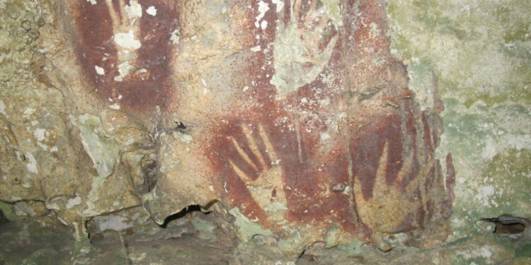
All but one of the sampled hand stencils (n = 6) from Southeast Sulawesi date to the Pleistocene, whereas the remaining paintings mainly consist of motifs with more recent (that is, Holocene) minimum ages (Supplementary Table 1). The oldest minimum-age constraint we obtained is for a hand stencil (sample LMET2) from Liang Metanduno in Muna Island (Fig. 2). This motif is partly covered by ancient coralloid speleothems. This stencil is in a poor state of preservation, comprising only a 14 × 10 cm patch of faded pigment bearing a portion of the fingers and the adjoining palm area. The tip of one finger appears to have been artificially narrowed, either through the additional application of pigment or by moving the hand during pigment application9, a distinct type of hand stencil art thus far identified only in Sulawesi10. Dating results show that this stencil was produced at least 67.8 thousand years ago (ka) (71.6 ± 3.8 ka) (Fig. 3). An additional coralloid speleothem (denoted as LMET1) was sampled over another hand stencil located on the same panel 11 cm to the left of the previous one (Fig. 4). This motif is also partly covered over by ancient coralloid speleothems, with only a portion of the original stencil remaining in the form of a 14 × 9 cm area of sprayed pigment bearing negative impressions of three fingers. The pigment appears darker in colour than the other visible hand stencils on the panel. Sample LMET1 comprises two distinct pigment layers embedded within the calcium carbonate. The stratigraphically oldest pigment layer has a minimum date of 60.9 ka (70.5 ± 9.5 ka), whereas the second pigment layer has a minimum date of 21.5 ka (22.8 ± 1.3 ka) and a maximum date of 32.8 ka (30 ± 2.8 ka). Close inspection shows that the darker pigment overlies the lighter pigment on the visible portion of the image. The lighter pigment may correspond to an earlier hand stencil or represent residual sprayed pigment associated with the hand stencil sampled as LMET2. Alternatively, the lighter layer may be the remains of a different motif, now obscured or no longer visible, that predates the overlying pigment. Regardless, it is evident from LMET1 that two episodes of Pleistocene rock art production on this panel are separated by a period of at least 35 kyr. Finally, as the oldest narrow-fingered stencil previously dated yielded a minimum date of 17 ka (ref. 1), we may conclude that this regionally unique variant of stencil art is much older than previously thought10.